Geostationary Satellite Orbit, GEO
- details of the basics of the geostationary earth orbit, GEO, used by satellites.
Satellite Orbits Includes:
Satellite orbit types & definitions
Low earth orbit, LEO
Geostationary orbit, GEO
Highly elliptical orbit HEO
Techniques for launching satellites into orbit
One very popular orbit format is the geostationary satellite orbit. The geostationary orbit is used by many applications including direct broadcast as well as communications or relay systems.
The geostationary orbit has the advantage that the satellite remains in the same position throughout the day, and antennas can be directed towards the satellite and remain on track.
This factor is of particular importance for applications such as direct broadcast TV where changing directions for the antenna would not be practicable.
It is necessary to take care over the use of the abbreviations for geostationary orbit. Both GEO and GSO are seen, and both also used for geosynchronous orbit.
Geostationary orbit development
The idea of a geostationary orbit has been postulated for many years. One of the possible originators of the basic idea was a Russian theorist and science fiction writer, Konstantin Tsiolkovsky. However it was Herman Oberth and Herman Potocnik who wrote about orbiting stations at an altitude of 35 900 km above the Earth that had a rotational period of 24 hours making it appear to hover over a fixed point on the equator.
The next major step forwards occurred when Arthur C Clarke, the science fiction write, published a serious article in Wireless World, a major UK electronics and radio publication, in October 1945. The article was entitled "Extra-Terrestrial Relays: Can Rocket Stations Give World Coverage?"
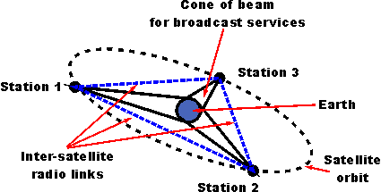
Clarke extrapolated what could be done with the German rocket technology of the day and looked at what might be possible in the future. He postulated that it would be possible to provide complete global coverage with just three geostationary satellites.

In the article, Clarke determined the orbital characteristics required as well as the transmitter power levels, the generation of solar power could be used, even calculating the impact of solar eclipses.
Clarke's article was well ahead of its time. It took until 1963 before NASA was able to start launching satellites that could test the theory. The first serviceable satellite able to start testing the theory was Syncom 2 which was launched on 26 July 1963. [Syncom 1 failed as it was unable to reach its correct geostationary orbit].
Geostationary orbit basics
As the height of a satellite increases, so the time for the satellite to orbit increases. At a height of 35790 km, it takes 24 hours for the satellite to orbit. This type of orbit is known as a geosynchronous orbit, i.e. it is synchronized with the Earth.
One particular form of geosynchronous orbit is known as a geostationary orbit. In this type of orbit the satellite rotates in the same direction as the rotation of the Earth and has an approximate 24 hour period. This means that it revolves at the same angular velocity as the Earth and in the same direction and therefore remains in the same position relative to the Earth.
In order to ensure that the satellite rotates at exactly the same speed as the Earth, it is necessary to clarify exactly what the time is for the rotation of the Earth. For most timekeeping applications, the Earth's rotation is measured relative to the Sun's mean position, and the rotation of the earth combined with the rotation around the Sun provide the length of time for a day. However this is not the exact rotation that we are interested in to give a geostationary orbit - the time required is just that for one rotation. This time period is known as a sidereal day and it is 23 hours 56 minutes and 4 seconds long.
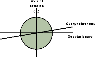
Geometry dictates that the only way in which an orbit that rotates once per day can remain over exactly the same spot on the Earth's surface is that it moves in the same direction as the earth's rotation. Also it must not move north or south for any of its orbit. This can only occur if it remains over the equator.

Different orbits can be seen from the diagram. As all orbital planes need to pass through the geo-centre of the Earth, the two options available are shown. Even if both orbits rotate at the same speed as the Earth, the one labelled geosynchronous will move north of the equator for part of the day, and below for the other half - it will not be stationary. For a satellite to be stationary, it must be above the Equator.
Geostationary satellite drift
Even when satellites are placed into a geostationary orbit, there are several forces that can act on it to change its position slowly over time.
Factors including the earth's elliptical shape, the pull of the Sun and Moon and others act to increase the satellite orbital inclination. In particular the non-circular shape of the of the Earth around the Equator tends to draw the satellites towards two stable equilibrium points, one above the Indian Ocean and the other very roughly around the other side of the World.. This results in what is termed as an east-west libration or movement back and forth.
To overcome these movements, fuel is carried by the satellites to enable them to carry out "station-keeping" where the satellite is returned to its desired position. The period between station-keeping manoeuvres is determined by the allowable tolerance on the satellite which is mainly determined by the ground antenna beamwidth. This will mean that no re-adjustment of the antennas is required.
Often the useful life of a satellite is determined by the time for which fuel will allow the station-keeping to be undertaken. Often this will be several years. After this the satellite can drift towards one of the two equilibrium points, and possibly re-enter the Earth's atmosphere. The preferred option is for the satellites to utilise some last fuel to lift them into a higher and increasing orbit to prevent them from interfering with other satellites.
Geostationary orbit coverage
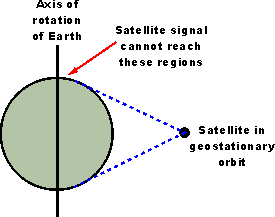
A single geostationary satellite obviously cannot provide complete global coverage. However, a single geostationary satellite can see approximately 42% of the Earth's surface with coverage falling off towards the satellite is not able to "see" the surface. This occurs around the equator and also towards the polar regions.

For a constellation of three satellites equally spaced around the globe, it is possible to provide complete coverage around the equator and up to latitudes of 81° both north and south.
The lack of polar coverage is not a problem for most users, although where polar coverage is needed, satellites using other forms of orbit are needed.
Geostationary orbit and path length / delay
One of the issues with using satellites in a geostationary orbit is the delay introduced by the path length.
The path length to any geostationary satellite is a minimum of 22300 miles. This assumes that the user is directly underneath the satellite to provide the shortest path length. In reality the user is unlikely to be in this position and the path length will be longer.
Assuming the shortest path length, this gives a single trip i.e. to the satellite or back of a minimum of around 120 milli-seconds. This means that the round trip from the ground to the satellite and back is roughly a quarter of a second.
Therefore to obtain a response in a conversation can take half a second as the signal must pass through the satellite twice - once on the outward journey to the remote listener, and then again with the response. This delay can make telephone conversations rather difficult when satellite links are used. It can also be seen when news reporters as using satellite links. When asked a question from the broadcasters studio, the reporter appears to take some time to answer. This delay is the reason why many long distance links use cables rather than satellites as the delays incurred are far less.
Advantages and disadvantages of geostationary orbit satellites
While the geostationary orbit is widely used for many satellite applications it is not suitable for all situations. There are several advantages and disadvantages to be taken into consideration:
Geostationary orbit advantages:
- Satellite always in same position relative to earth - antennas do not need re-orientation
Geostationary orbit disadvantages:
- Long path length, and hence losses when compared to LEO, or MEO.
- Satellites more costly to install in GEO in view of greater altitude.
- Long path length introduces delays.
- Geostationary satellite orbits can only be above the equator and therefore polar regions cannot be covered.
Despite the disadvantages of using satellites in geostationary orbit, they are still widely used because of the overriding advantage of the satellite always being in the same position relative to a given place on the Earth.
 Written by Ian Poole .
Experienced electronics engineer and author.
More Essential Satellite Topics:
Interesting facts about satellites
Satellite orbits
Solar outage
Return to Satellite topics menu . . .


