What is Satellite Navigation SatNav, GNSS
Satellite Navigation Systems, SatNav or GNSS Global Navigation Satellite Systems are now used in all walks of life: the technology and operation is well established but requires extreme accuracy.
GNSS / SatNav Includes:
SatNav / GNSS basics
Satellite Navigation, or SatNav is an accepted part of everyday life. SatNav is included in most new cars today, and the technology is incorporated into most new smartphones allowing them to be used to detect the location of the phone and enable localised ads to be sent as well as providing mapping and direction giving for use walking and in cars, etc.
The first SatNav system was known as GPS, Global Positioning System, but now others are available or being brought into service.
Most satellite navigation systems in use today provide world wide coverage and are therefore known as GNSSs, Global Navigation Satellite Systems. Typically using medium earth orbits, these systems provide very accurate navigation and time signals, allowing users to find their position to a few metres or less on the Earth's service, whilst other users can extract an exceedingly accurate time signal.
SatNav GNSS basics
The basic concept behind satellite navigation or GNSS systems is that signals are transmitted from the satellites in space and these are received by the receivers on or near to the surface of the earth. Using timing it is possible to determine the distance from each satellite and thereby using a process of triangulation and a knowledge of the satellite positions the position on Earth can be determined.
The satellites all send timing information so the receiver knows when the message was sent. As radio signals travel at the speed of light they take a very short but finite time to travel the distance from the satellite to the receiver. The satellites also transmit information about their positions. In this way the receiver is able to calculate the distance from the satellite to the receiver.
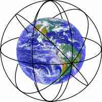
The satellites in a SatNav or GNSS system typically orbit in a medium Earth orbit. There are normally three orbits each having four operational satellites. This set-up gives sufficient satellites in view so that any ground user has sufficient in view to gain an accurate fix. This can obviously only occur if the user is not shielded by tall buildings, etc.
The original use for the first GNSS called GPS was for military use, and this is still one of the main drivers for their operation. However domestic and commercial users are also allowed access, although this may not be to the same accuracy.
The signals from the GNSS satellites are often transmitted in L band around 1500 MHz, and although the received signals are weak, the advanced techniques used enable the receivers to pick out the data on Earth.
The satellites are controlled to an exceedingly high degree of accuracy but ground stations. These are located around the globe at strategic points, so that status data can be received and correction data can be applied, and the satellites controlled from Earth.
The GNSS SatNav satellite orbits are tightly controlled because errors in their orbit will translate to errors in the final positions. The time signals are also tightly controlled. The satellites contain an atomic clock so that the time signals they transmit are very accurate. Even so these clocks will drift slightly and to overcome this, signals from Earth stations are used to correct this.
For most of the GNSS SatNav systems a number of spares are launched so that if one satellite fails another can quickly enter service.
The satellites are subject to the rigours of outer space and can fail as a result of many causes including solar storms, etc, and therefore it is essential to have spares that can quickly enter service. The US based GPS, NavStar system has 24 active satellites and a number of spares dependent upon how many have failed before further replacements can be placed into orbit..
Different SatNav systems
There are several different GNSS or SatNav systems that have come on line, or are in the process of being deployed:
- GPS - Global Position System: GPS is the SatNav system owned and operated by the USA. It consists of up to 32 satellites in six orbits. The exact number of satellites varies as older satellites are retired and replaced. The system first became operational in 1978 although it was globally available after 1994. In view of the length of time it has been operational, it is the most widely used system.
- Galileo: Galileo is the GNSS developed by the European Union. Early operational capability became available in 2016 and it is expected to reach full operational capability by 2020. The aim is that Galileo will be used in the modernized GPS system with SatNav receivers combining the signals from both Galileo and GPS satellites to to provide significantly improved accuracy.
- GLONASS: The letters GLONASS stand for Global'naya Navigatsionnaya Sputnikovaya Sistema, (GLObal NAvigation Satellite System). This GNSS SatNav system is owned and operated by Russia to provide a civilian radio navigation using satellite technology. It is also used by the Russian Aerospace Defence Forces. The system provides full global coverage using 24 satellites.
- BeiDou: The Chinese BaiDou GNSS or SatNav system has undergone several generations. The BaiDou-3 system will consist of 30 satellites in medium earth orbit and five in geostationary orbit. The complete global system was completed in December 2018.
 Written by Ian Poole .
Experienced electronics engineer and author.
More Essential Satellite Topics:
Interesting facts about satellites
Satellite orbits
Solar outage
Return to Satellite topics menu . . .